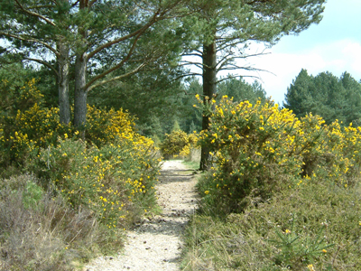
Stephens Castle is a pleasant and popular place for walkers and wildlife enthusiasts, with magnificent views from the higher ground across south east Dorset, and footpath links to North Ringwood Forest.
The 'Castle' is a Bronze Age barrow at the top of an old sand and gravel quarry, and is a Scheduled Ancient Monument. Legend has it that Stephen was a local tribal chief of great strength. He was supposed to have hurled the 'Stephen stone' half a mile into Ringwood Forest, no mean feat as the stone weighs around 3 tonnes! The barrow was excavated by archaeologists in 1828, where human remains dating back to the Bronze Age were found.
Verwood once had a thriving pottery and brick industry which stemmed from the abundance of clay, and fuelled by the gorse and birch found on the heaths. The arrival of the railway brought a change to the fortunes of the people of Verwood in 1866 by making lighter enamel goods more easily obtainable from around the country. This resulted in the traditional management techniques being abandoned. Stephens Castle itself was formerly used as a mineral quarry which changed the topography dramatically.
A fire in Spring 2015 damaged part of the site but it is now making a good recovery.
| Nearest Town | Verwood |
|---|---|
| Look out for | The heathland is home to many rare plants and animals, including Sand Lizards, Smooth Snakes, Grayling, Small Heath, Nightjar, Stonechat and Dartford Warbler. Ponds on the heath also support several species of Dragonfly and Damselfly and all three newt species. It also contains round and oblong leaved sundew. The south east corner of the site is home to huge swathes of Bog Asphodel and the smaller of the two ponds contains Bladderwort, which can be seen flowering in July. This is a protected insectivorous species that forms a network of underwater bladders which trap the food. |
| Habitats | Wet and dry lowland heath |
| Site designations | Local Nature Reserve, Site of Special Scientific Interest, Scheduled Ancient Monument, Site of Nature Conservation Interest |
| Nearest bus stop | Ringwood Road, Wilts and Dorset bus route |
| Nearest train station | Bournemouth (15 miles) |
| Grid reference | SU 090 094 |
| Size | 20 hectares |
| Parking | Parking is available at the side of Moorlands Road but please do not block access to the Verwood Brass Band HQ or the British Legion. |
| Accessibility | Open Access area, some paths are very sandy in places and there are some quite steep slopes, accessible kissing gates at all entrances. 1 mile circular all weather path starting and finishing from the rear of Hillside School. |
| Facilities | Dog bins at most entrances |
| Owner | Dorset Council (Previously East Dorset District Council) |
| Managed by | Dorset Council Countryside Team |
| How to get there | From Ringwood Road (B3081) heading west, pass the recreation ground on your right and continue to a roundabout. Take the last exit turning right and follow the road up to another roundabout. Take the last exit turning right again. Follow the signs for the British Legion which will lead you into Moorlands Road. From 3-Legged Cross (Manor Road, B3072) keep heading north towards Verwood. When you get to the cross road with Ringwood Road turn left and continue to a roundabout. Take the last exit turning right and follow the road up to another roundabout. Take the last exit turning right again. Follow this road around into Moorlands Road. |
Greenspace Team East
Email: greenspaceseast@dorsetcouncil.gov.ukTel: 01425 483809
Full contact details


